Student Notable
Service Design Award
Core77 Design Awards 2015
JIMOTO
We believe that modern navigation should be easier to use, more engaging and should actually improve one's spacial memory, as opposed to impairing it. Our team observed that modern GPS systems are not designed for short-distance, on-foot journeys. Navigating today is a passive process, often leaving the user without the ability to recall how they travelled to their destination.
With the Jimoto map and system, we created a more natural mapping experience that you can access on our app or in a convenience store location. We combined both birds-eye view and street view, to give users visual cues as they use the map. We also simplified the map to include just the necessary landmarks so that users are not overwhelmed by too much information. Jimoto gives the option to customize which visual landmarks are used, for example colors, logos, signage, etc. This is all to create a more natural and personalized mapping experience. With our mobile application and our convenience store application that fits into an existing system, it is easy to access Jimoto whether you have data on your phone, or if you a tourist visiting a new area.
Traditional GPS systems can weaken one's special memory because they do not engage the user and the hippocampus portion (spacial memory portion) of the brain. GPS applications are the number 1 most used mobile application. Not engaging this portion of the brain long-term by depending upon traditional GPS applications will lead to an increase in early onset Alzheimer's disease and dementia in the world. With Jimoto the user is forced to landmark match, the user is active in their navigation and the hippocampus is engaged. With the use of Jimoto, people will find navigating their cities more engaging, more memorable and more enjoyable, all while developing their spacial memory.
 Jimoto
2014
Jimoto
2014
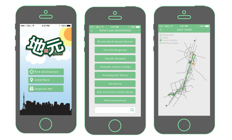 Jimoto Smart Phone Application
User Interface of Jimoto Smart Phone Application
2014
Jimoto Smart Phone Application
User Interface of Jimoto Smart Phone Application
2014
 Jimoto Convenience Store In-Store Application
User Interface Sample of Jimoto In-Store Application
2014
Jimoto Convenience Store In-Store Application
User Interface Sample of Jimoto In-Store Application
2014
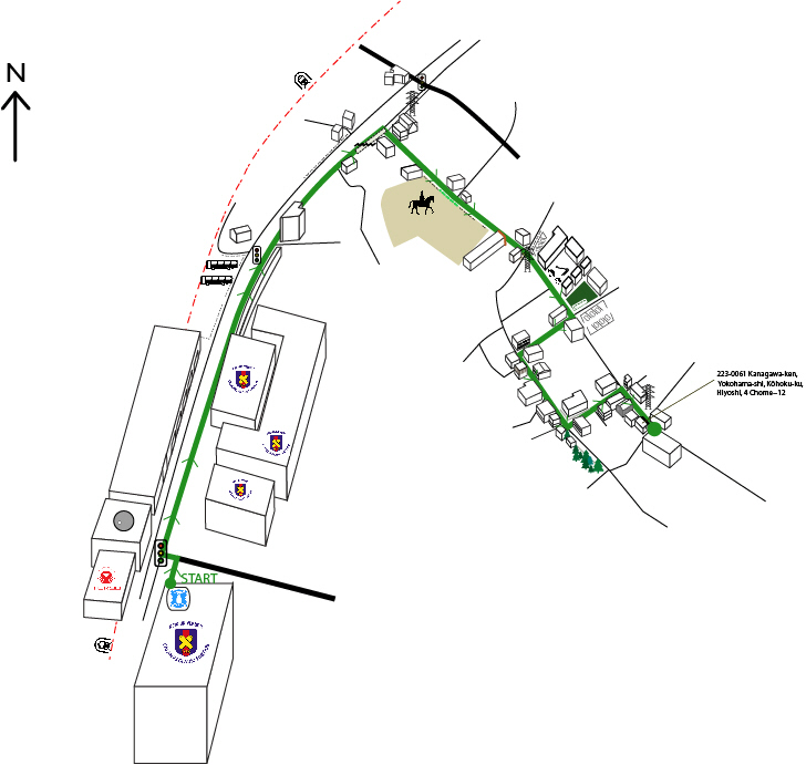
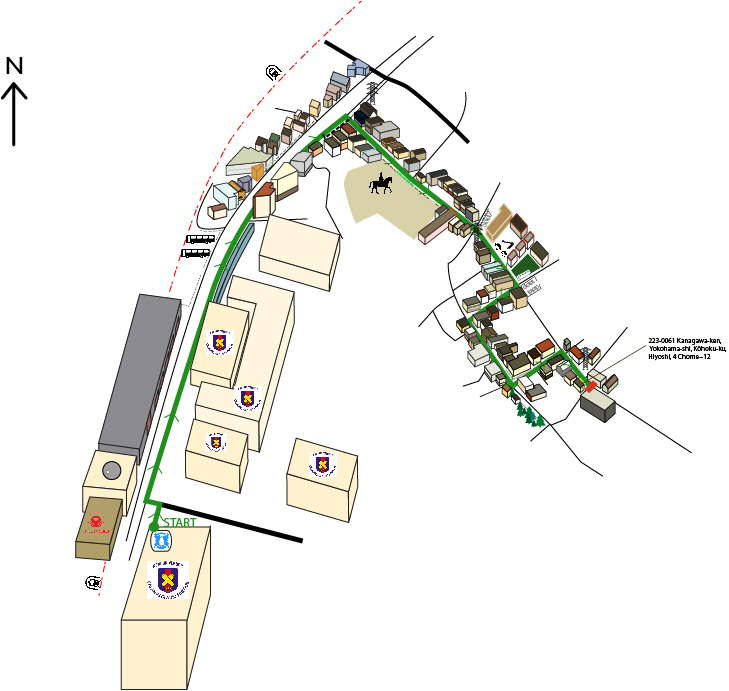
 Jimoto Map - Version A MINIMAL
Birds-eye view and street view are combined to give users visual cues as they use the map. The map is simplified to include just the necessary landmarks so that users are not overwhelmed by too much information. Jimoto gives the option to customize which visual landmarks are used, for example colors, logos, signage, etc. This is all to create a more natural and personalized mapping experience.
2014
Jimoto Map - Version A MINIMAL
Birds-eye view and street view are combined to give users visual cues as they use the map. The map is simplified to include just the necessary landmarks so that users are not overwhelmed by too much information. Jimoto gives the option to customize which visual landmarks are used, for example colors, logos, signage, etc. This is all to create a more natural and personalized mapping experience.
2014
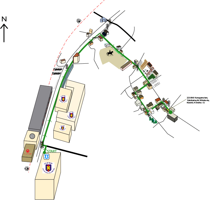
 Jimoto Map - Version B LOGO
Birds-eye view and street view are combined to give users visual cues as they use the map. The map is simplified to include just the necessary landmarks so that users are not overwhelmed by too much information. Jimoto gives the option to customize which visual landmarks are used, for example colors, logos, signage, etc. This is all to create a more natural and personalized mapping experience.
2014
Jimoto Map - Version B LOGO
Birds-eye view and street view are combined to give users visual cues as they use the map. The map is simplified to include just the necessary landmarks so that users are not overwhelmed by too much information. Jimoto gives the option to customize which visual landmarks are used, for example colors, logos, signage, etc. This is all to create a more natural and personalized mapping experience.
2014
 Jimoto Map - Version C COLOR
Birds-eye view and street view are combined to give users visual cues as they use the map. The map is simplified to include just the necessary landmarks so that users are not overwhelmed by too much information. Jimoto gives the option to customize which visual landmarks are used, for example colors, logos, signage, etc. This is all to create a more natural and personalized mapping experience.
2014
Jimoto Map - Version C COLOR
Birds-eye view and street view are combined to give users visual cues as they use the map. The map is simplified to include just the necessary landmarks so that users are not overwhelmed by too much information. Jimoto gives the option to customize which visual landmarks are used, for example colors, logos, signage, etc. This is all to create a more natural and personalized mapping experience.
2014
 Jimoto Map - Version D TRUE TO LIFE
Birds-eye view and street view are combined to give users visual cues as they use the map. The map is simplified to include just the necessary landmarks so that users are not overwhelmed by too much information. Jimoto gives the option to customize which visual landmarks are used, for example colors, logos, signage, etc. This is all to create a more natural and personalized mapping experience.
2014
Jimoto Map - Version D TRUE TO LIFE
Birds-eye view and street view are combined to give users visual cues as they use the map. The map is simplified to include just the necessary landmarks so that users are not overwhelmed by too much information. Jimoto gives the option to customize which visual landmarks are used, for example colors, logos, signage, etc. This is all to create a more natural and personalized mapping experience.
2014
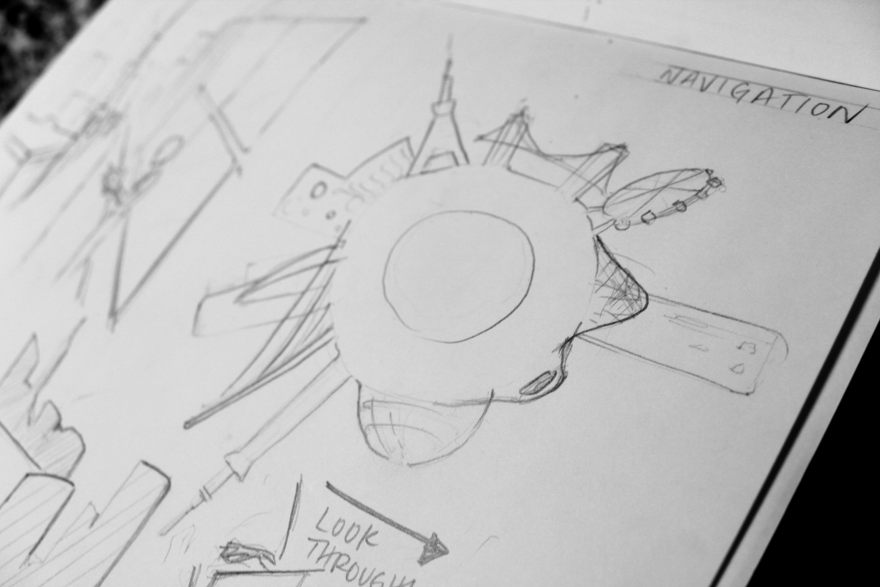
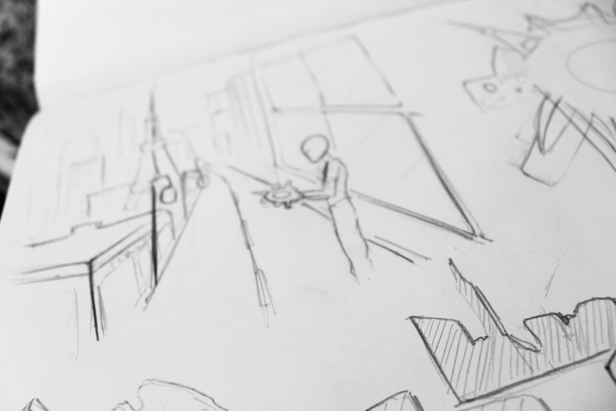 Ideation and Sketches
2014
Ideation and Sketches
2014
 Ideation and Sketches
2014
Ideation and Sketches
2014
 Sketch Model Process Work
2014
Sketch Model Process Work
2014
We believe that modern navigation should be easier to use, more engaging and should actually improve one's spacial memory, as opposed to impairing it. Our team saw and opportunity: modern navigation smart-phone applications don't facilitate natural means of navigating. These systems ask their users to follow directions without ever necessarily looking up, and without developing one's spacial memory as one would without any digital aid. Our team observed that modern GPS systems are not designed for short-distance, on-foot journeys. Navigating today is a passive process, often leaving the user without the ability to recall how they travelled to their destination.
Our process in developing this design started with many sketches and sketch models. We began by researching and studying navigation – environmental graphic design, way finding, the different GPS systems and applications currently available, tour maps, artistic maps, old maps (and compared the information displayed to the information displayed on newer maps), and even how animals and sailors navigate. As the project and the models progressed, the clarity of what we wanted to accomplish with our design became ever clearer. Our team wanted a more fun, engaging map that developed 'mental mapping' skills for the user. We 3D-printed tactile versions of the map, and played with the idea of a landmark 'wheel' which would allow the user to use relative locations of landmarks to quickly find the general direction they should be moving in. When users in testing were finding this difficult to use and understand, we decided to go backward and think again about how we could translate our strategy of landmark matching into something visual.
We decided to create this simplified combined birds-eye/street-view map with a customizable feature. In testing of this newest map with different users, all successfully travelled from their starting point to their unknown ending point without any outside assistance, while progressing at a medium speed. All users agreed that using the map was fun and that they would want to use it again even though it was slightly more time consuming than some GPS systems. Without provocation they all stated that they were willing and enthusiastic to use the map design again.
With the Jimoto map and system, we created a more natural mapping experience that you can access on our app or in a convenience store location. We combined both birds-eye view and street view, to give users visual cues as they use the map. We also simplified the map to include just the necessary landmarks so that users are not overwhelmed by too much information. Jimoto gives the option to customize which visual landmarks are used, for example colors, logos, signage, etc. This is all to create a more natural and personalized mapping experience. With our mobile application and our convenience store application that fits into an existing system, it is easy to access Jimoto whether you have data on your phone, or if you a tourist visiting a new area.
This project continues to be ever more relevant and important since GPS applications are the number 1 most used mobile application in the world. Navigating is something that affects all of our lives, whatever one's financial bracket, age or location. Even though each Jimoto map is specific from location to location, this issue undoubtedly has global importance if is to effect the number of countries that use mostly traditional GPS systems. These existing systems do not engage the user and the hippocampus portion (spacial memory portion) of the brain. Not engaging this portion of the brain long-term by depending upon traditional GPS applications will lead to an increase in early onset Alzheimer's disease and dementia in the world. With Jimoto the user is forced to landmark match, the user is active in their navigation and the hippocampus is engaged. With the use of the Jimoto system, people will find navigating their cities more engaging, more memorable and more enjoyable, all while developing their spacial memory.
Jury Commentary
Looked at a specific use case and clear pain point
This project took what I see as a ubiquitous part of mobile life, the GPS apps on our phones, but looked at a specific use case and clear pain point- how to get from A to B when you're walking and want to explore, but don't necessarily need specific directions. This is something most map applications don't really help you with.